|
Frid macht
reichtum, reichtum macht hochfart,
hochfart macht unainigung, unainigung macht krieg,
krieg macht armut, armut macht diemutikait,
diemutikait macht fried.
notebook
Frederick III (1415–1493)
Wir lesen im Raum die
Zeit.
Friedrich Ratzel (1844–1904)
anthropogeograph
book article
- Joachim Laczny: Friedrich III. (1440–1493) auf Reisen. Die
Erstellung des Itinerars eines spätmittelalterlichen
Herrschers unter Anwendung eines Historical Geographic Information
System (Historical GIS), in: Perzeption und Rezeption. Wahrnehmung und
Deutung im Mittelalter und in der Moderne, hrsg. Joachim Laczny,
Jürgen Sarnowsky (Nova Mediaevalia Quellen und Studien zum
europäischen Mittelalter, 12), Göttingen 2014, p.
33–65, DOI: 10.14220/9783737002486.33. (with 7 graphs and 5 maps) (Find a copy, Import: RIS)
Abstract: With the help of
technology the German King and Emperor Frederick III who reigned from
1440 until 1493, has come more into the focus of historical research.
In previous decades he was not as highly respected as a medieval ruler
but new research methods have brought him into a better light. The
collection of sources - the Regesta Imperii - concerning the
emperor’s government is not only printed, but is available as
a database with over 18,400 registers of decrees online.
Using these datasets - including the parameters of time and space for
each historical document - a Historical GIS (Geographical Information
System, HGIS, Digital Humanities) was designed. An interactive map
gives direct access to the
collection of sources in time and space. Were there any stationary or
mobile phases during Fredrick’s III reign? Which time periods
did these phases cover?
The analysis using a Historical GIS showed that Frederick III was a
very mobile monarch in the typical medieval style, but at the same time
he was already developing centres of power like Wiener Neustadt.
Because of this Frederick III can he classified as a ruler at a turning
point in history.
The master-thesis (Magister Artium) was supervised by Prof. Dr.
Jürgen Sarnowsky, History Department, Middle Ages, at the University
of Hamburg
in 2007/2008.
conference
presentations
- Friedrich III. (1440–1493) auf Reisen. Die
Erstellung des Itinerars eines spätmittelalterlichen
Herrschers unter Anwendung eines historisch-geographischen
Informationssystems (his-GIS). Internationale EDV-Tagung: Workshop
"Digitalisierung von Opferdaten der NS-Zeit" trifft
"Arbeitsgemeinschaft Geschichte und EDV" (AGE), Weiden/Opf., 28./29.
Oktober 2010.
- The late medieval ruler Frederick III
(1440–1493) on the journey – the creation of the
itinerary using a Historical GIS (his-GIS). European Social Science
History Conference, Gent, Belgien, 13.–16. April 2010.
- The late medieval ruler Frederick III
(1440–1493) on the journey – the creation of the
itinerary using a Historical GIS (his-GIS). Im Panel
„Journeys, travel and geography“. Social Science
History Association-Tagung: “Agency and Action“,
Long Beach, Kalifornien, USA, 12.–15. November 2009.
supplement
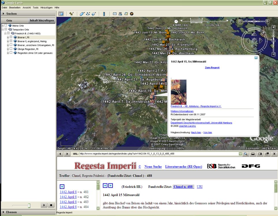
animations
interactiv-dynamic map
 View
via GOOGLE Earth (1,5 MB) (KMZ/KML) View
via GOOGLE Earth (1,5 MB) (KMZ/KML)
datasets
- dataset I:
Regesta Imperii - XIII. Abteilung: Friedrich III.,
6.11.2007, 18,000 datasets
(By kind permission of Prof. Dr. Paul-Joachim Heinig and support during
the export process by Dr.
Andreas Kuczera)
- dataset II:
Heinig, Paul Joachim: Kaiser Friedrich III. (1440–1493): Hof,
Regierung
und Politik (Forschungen zur Kaiser- und Papstgeschichte des
Mittelalters, 17), Vol. 3, Köln, Weimar, Wien 1997, p.
1347–1389, 405 datasets
|
